A4 Cycle Route and Road Safety Improvements
Overview
UPDATE Monday 25 September 2023: We've extended the consultation closing date to 11.59pm on Friday 29 September 2023.
We consult residents, commuters, businesses, and stakeholders to understand what people think about proposed developments, changes to our roads and pavements, or other traffic-related issues.
We have developed proposals for a new off-road, mostly segregated, two-way, cycle route alongside the A4 between Huntercombe Lane and Uxbridge Road, with associated road safety improvements along the A4, and we would like your views on these.
Background
An A4 Cycle Route
In 2021 we assessed the existing cycling and walking facilities along the A4 between Huntercombe Lane and Uxbridge Road, and looked at how the route could be changed to accommodate all levels of cycling ability, while also making walking improvements where we can. In Autumn 2021 we asked for people’s views on their active travel journeys in Slough, and about cycling and walking facilities along this section of the A4
A4 Safer Roads Scheme
A4 Safer Roads – General
In 2021 we reviewed the A4 through Slough to identify and propose road safety measures, following the award of close to £1.7 million from the Department for Transport’s Safer Roads Fund. We asked for people’s views on this.
A4 Safer Roads – Speed Limit Reduction
In 2022 we asked for people’s views on reducing speed limits along the A4.
We have now developed proposals for a new off-road, mostly segregated, two-way, cycle route alongside the A4 between Huntercombe Lane and Uxbridge Road, with associated road safety improvements along the A4. These changes would be funded by the Department for Transport (DfT), and would improve cycling facilities and reduce the number and severity of collisions on the A4 in Slough. We would like your views on them.
Why are we proposing these changes?
Motorised transport in urban areas of England is associated with poor air quality, congestion, collisions and physical inactivity (Department for Transport, 2009).
Air pollution is damaging to our environment and to our health, and road transport is responsible for 80% of the pollution where legal limits are being broken, including in Slough where there are four Air Quality Management Areas (AQMAs). Air pollution has a number of health consequences, particularly for some demographic groups, with up to 40,000 early deaths attributable to it each year in the UK. It has been linked to cancer, asthma, stroke and heart disease, diabetes, obesity, and changes linked to dementia. It particularly affects children and older people because of their age, as well as those with existing respiratory conditions. It also contributes to health inequalities, because deprived communities are often in areas with higher levels of pollution near busy roads, and people who can afford to do so tend to choose to live in quieter, cleaner streets. Also, studies have suggested that people can experience greater levels of pollution in vehicles than when walking or cycling in the same environment.
Analysis of the forces driving climate change has found that motor vehicles are the greatest contributor to atmospheric warming worldwide. They release pollutants and greenhouse gases that promote warming, while emitting few aerosols that counteract it.
The majority (68%) of journeys in the UK are under five miles, with 19% of journeys being less than one mile. These short journeys are amenable to walking and cycling for most people and are particularly relevant in improving air quality as if made in motor vehicles they contribute disproportionately to emissions, due to vehicle engines starting from cold and due to some emissions that persist after the vehicle has stopped.
Slough has significant deficiencies in its residents’ life expectancy, deaths attributed to air pollution, child obesity and adult levels of physical activity when compared to its neighbours or to England as a whole. These health inequalities in Slough are partly due to the town’s built and natural environments, including its transport infrastructure. The fewer opportunities there are for active transport (cycling and walking) the more motorised transport journeys occur.
Strategies to reduce motor vehicle use, particularly for short journeys, are therefore needed to reduce the consequences of both urban air pollution and climate change.
To reduce motor vehicle use and address health inequalities we must improve access to active transport in Slough. Providing more routes for cycling and walking, and promoting these forms of physical activity and transport, encourage people to make positive changes to their lifestyle and behaviours, which then improve health outcomes. These health outcomes include reduced risk of coronary heart disease, stroke, cancer, obesity and type 2 diabetes, a healthy musculoskeletal system, and good mental wellbeing (National Institute for Health and Care Excellence (NICE). 2012).
Enabling and encouraging people to cycle or walk requires action on many fronts, and by many different sectors, including environmental, social, financial, and personal.
More cycling and walking (as forms of transport and as recreational activities) can reduce car travel, leading to reductions in air pollution, carbon dioxide emissions and congestion. They can also reduce road danger, reduce noise, and increase the number of people of all ages who are out on the streets, making public spaces more welcoming and providing more opportunities for social interaction, thus reducing social isolation (NICE, 2012).
By constructing the A4 mostly segregated cycle route and associated road safety improvements we would enable and encourage Slough residents, workers, and visitors to cycle and walk more often, both as forms of transport and as recreational activities.
What are we proposing?
We are proposing a new off-road, mostly segregated, two-way, cycle route alongside the A4 between Huntercombe Lane and Uxbridge Road, with associated road safety improvements along the A4.
The cycle route would be approximately 2.5 metres wide throughout. We would provide a continuous, raised cycle route and footway across the side road at most non-signalised side road junctions, to reduce the speeds of turning vehicles, improving convenience and safety for cyclists and pedestrians. We would remove some pedestrian guardrail, and upgrade most of the signalised junctions along the route with new traffic signals, to improve safety for cyclists and pedestrians.
We would make some other changes to roads, footways, verges, bus stops, and traffic signals along the A4, to accommodate the cycle route, to improve safety for all, including cyclists and pedestrians, and to balance the needs of all road users.
We have divided the A4 cycle route proposals into three construction phases:
- Phase 1: A4 Bath Road: between Huntercombe Lane North and Dover Road
- Phase 2: A4 Bath Road: between Dover Road and Pitts Road
- Phase 3: A4 Bath Road, A4 High Street, A4 Wellington Street: between Pitts Road and Uxbridge Road
Please see below for plans for each phase, and a list of the main proposed changes, for the A4 Cycle Route.
Phase 1: A4 Bath Road: between Huntercombe Lane North and Dover Road
In this phase we would construct a cycle route of approximately 2.5 metres wide alongside the footway for approximately 1.85km along the northern side of the A4 Bath Road.
In some areas we would change the footway and grass verge to accommodate the cycle route.
Phase 1: Plan 1A (Sheet 1 of 8) - Huntercombe Lane North - Whittle Parkway
Phase 1: Plan 1B (Sheet 2 of 8) - Whittle Parkway - Opposite Citygate Garage
Moving from west to east, the main proposed changes include:
- Huntercombe Lane North / Huntercombe Lane South junction (see Figs. 1a and 1b below):
- A new dedicated cycle phase in the traffic signals, to help cyclists cross the A4 Bath Road to and from the cycle route to the west (in Buckinghamshire) which is on the south side of the A4 Bath Road
- Removal of the eastbound bus stop layby; buses would stop in the main traffic lane, with bus passengers crossing the cycle route to get on and off buses
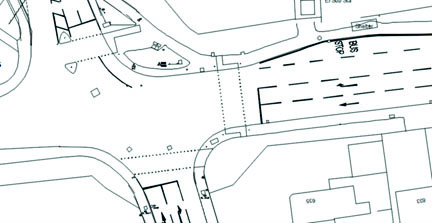
Fig. 1a: Huntercombe Lane North / Huntercombe Lane South junction – existing arrangement
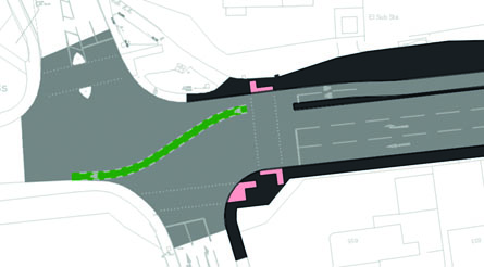
Fig. 1b: Huntercombe Lane North / Huntercombe Lane South junction – proposed arrangement
- Goldsworthy Way junction (the Huntercombe Spur Roundabout) (see Figs. 2a and 2b below):
- A new parallel crossing across Goldsworthy Way (this is a zebra crossing which also allows cyclists to cross alongside at the same location)
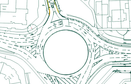
Fig. 2a: Goldsworthy Way (the Huntercombe Spur Roundabout) – existing arrangement
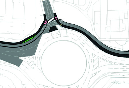
Fig. 2b: Goldsworthy Way (the Huntercombe Spur Roundabout) – proposed arrangement
- Just east of the Huntercombe Spur Roundabout (see Figs. 3a and 3b below):
- Opening up the north side service road after the Huntercombe Spur Roundabout, to enable vehicle access to properties and businesses
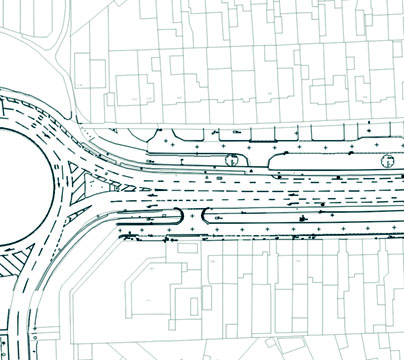
Fig. 3a: Just east of the Huntercombe Spur Roundabout – existing arrangement
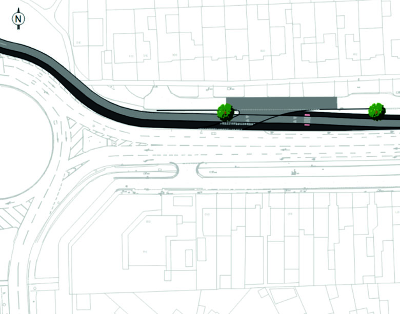
Fig. 3b: Just east of the Huntercombe Spur Roundabout – proposed arrangement
- St Andrews Way / Whittle Parkway junctions (see Figs. 4a and 4b below):
- Removal of the eastbound left turn from the A4 Bath Road into the north side service road by the Mini garage
- Removal of the westbound right turn from the A4 Bath Road into the north side service road by the Mini garage
- Closure of access between St Andrews Way and the south side service road east of St Andrews Way
- A new dedicated signalised cycle crossing across the A4 Bath Road west of the St Andrews Way junction and new westbound traffic signals at the Whittle Parkway junction
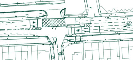
Fig. 4a: St Andrews Way / Whittle Parkway junctions – existing arrangement
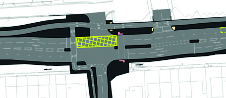
Fig. 4b: St Andrews Way / Whittle Parkway junctions – proposed arrangement
- Elmshott Lane / Station Road junction (see Figs. 5a and 5b below):
- Upgrading of the existing traffic signals including a new ‘CYCLOPS’ junction (‘CYCLOPS’ (cycle optimised protected signals) contains an orbital cycle route with signalised crossing facilities that separate cyclists from motor traffic, reducing the likelihood of collisions and conflicts – see Image 1 below)
- Making small changes to the free car park west of Elmshott Lane
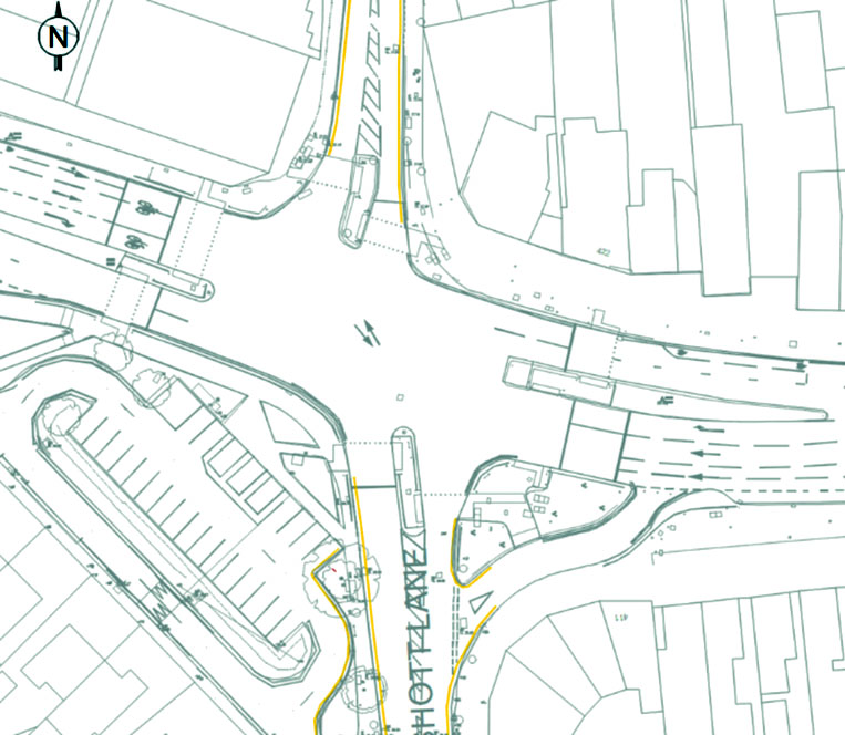
Fig. 5a: Elmshott Lane / Station Road junction – existing arrangement
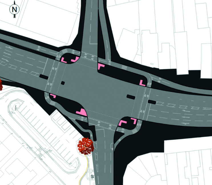
Fig. 5b: Elmshott Lane / Station Road junction – proposed arrangement
- Burnham Lane and Bath Road Shopping Park junctions (see Figs. 6a and 6b below):
- Introduction of new countdown timers for pedestrians at existing signalised crossings (these show the amount of time left to cross the road before the red man appears – see Image 2 below)
- Widening of existing cycle lane alongside Bath Road Shopping Park to 3 metres
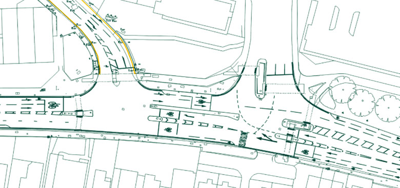
Fig. 6a: Burnham Lane and Bath Road Shopping Park junctions – existing arrangement
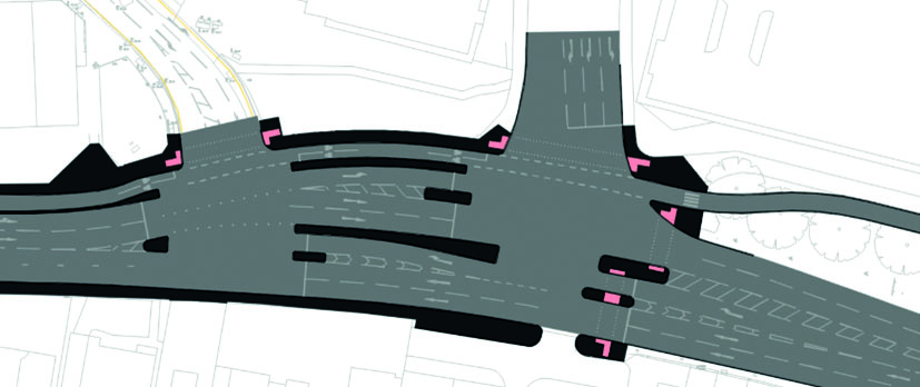
Fig. 6b: Burnham Lane and Bath Road Shopping Park junctions – proposed arrangement
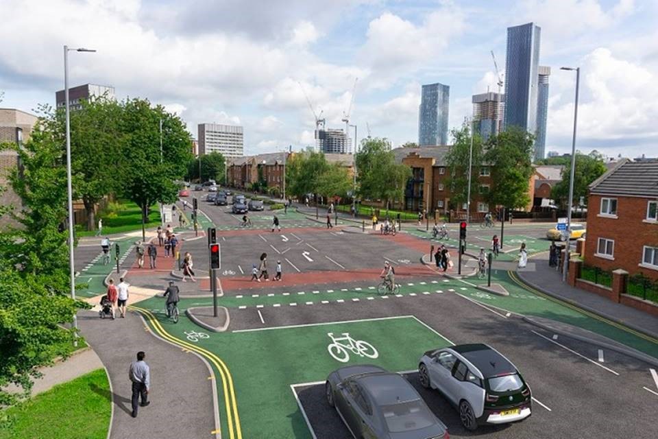
Image 1: A ‘CYCLOPS’ junction (this example is not in Slough) (Source: Road Safety GB)
Phase 2: A4 Bath Road: between Dover Road and Pitts Road
In this phase we would construct a cycle route of approximately 2.5 metres wide for approximately 1.48km along the southern side of the A4 Bath Road.
We would upgrade the existing segregated cycle path, and convert the existing shared use path, to a segregated cycle route. We would maintain the existing pedestrian footway, although in some areas we would change the footway and grass verge to accommodate the cycle route.
Phase 2: Plan 2A (Sheet 3 of 8) - Dover Road - Westgate Crescent (Same Plan as Phase 1: Plan 1C)
Phase 2: Plan 2B (Sheet 4 of 8) - Westgate Crescent - Atria
Phase 2: Plan 2C (Sheet 5 of 8) - Atria - Pitts Road
Moving from west to east, the main proposed changes include:
- Westgate Retail Park (plan extracts not available):
- Removal of the westbound bus stop layby; buses would stop in the main traffic lane
- Twinches Lane junction (see Figs. 7a and 7b below):
- Closure of exit from the south side service road, west of Twinches Lane, into Twinches Lane, to prevent vehicles using the service road as a short cut
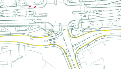
Fig. 7a: Twinches Lane junction – existing arrangement
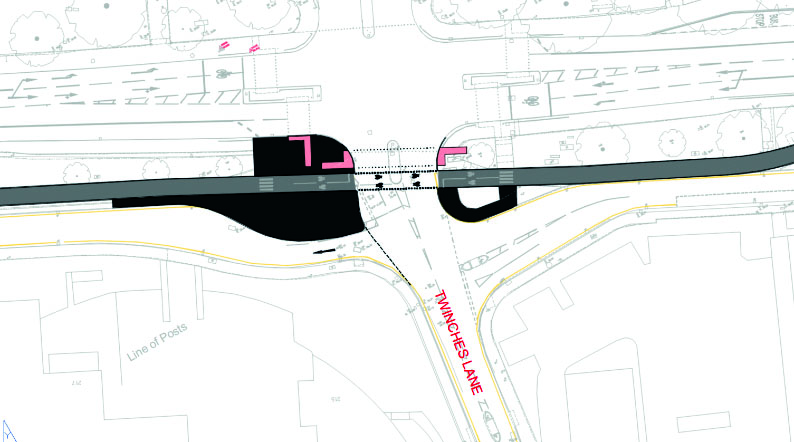
Fig. 7b: Twinches Lane junction – proposed arrangement
Phase 3: A4 Bath Road, A4 High Street, A4 Wellington Street: between Pitts Road and Uxbridge Road
In this phase we would construct a cycle route of approximately 2.5 metres wide for approximately 2.49km along the northern side of the A4 Bath Road.
The cycle route would run alongside the footway between the Pitts Road and the Wellington Street / High Street junctions. We would upgrade the existing shared use path between the Wellington Street / High Street junction and the Tesco store. We would upgrade the existing segregated cycle path alongside the Tesco store, and upgrade the existing shared use path between the Tesco store and the Uxbridge Road junction. Between the Farnham Road / Tuns Lane (The Three Tuns) junction and the Wellington Street / High Street junction we would narrow parts of the central reservation.
Phase 3: Plan 3A (Sheet 6 of 8) - Pitts Road - Salt Hill Park
Phase 3: Plan 3B (Sheet 7 of 8) - Salt Hill Park - Wellington Street High Street Junction
Phase 3: Plan 3C - Wellington Street High Street Junction - Tesco (plan not available)
Phase 3: Plan 3D (Sheet 8 of 8) - Tesco - Wexham Road
Phase 3: Plan 3E - Wexham Road - Uxbridge Road (plan not available)
Moving from west to east, the main proposed changes include:
- Pitts Road junction (see Figs 8a and 8b below):
- Upgrading the existing signalised pedestrian crossing to include signalised cycle crossing facilities
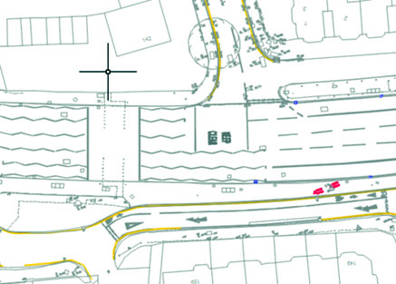
Fig. 8a: Pitts Road junction – existing arrangement
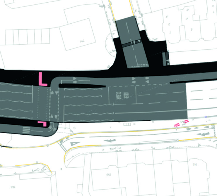
Fig. 8b: Pitts Road junction – proposed arrangement
- Farnham Road / Tuns Lane (The Three Tuns) junction (see Figs 9a and 9b below):
- Removal of the eastbound left turn slip road from the A4 Bath Road into Farnham Road, with the turn to be made using the main carriageway
- Removal of the southbound left turn slip road from Farnham Road into the A4 Bath Road, with the turn to be made using the main carriageway
- Reduction of the eastbound right turn from the A4 Bath Road into Tuns Lane from two lanes to one lane
- Reduction of the westbound right turn from the A4 Bath Road into Farnham Road from two lanes to one lane
- Improvements to the service road and the left turn lane on the south west corner of the junction, to deter inconsiderate parking and improve safety for cyclists and pedestrians
- Reduction of the northbound right turn from Tuns Lane into the A4 Bath Road from two lanes to one lane, to improve road safety (not yet shown in Fig. 9b below or Plan 3A above)
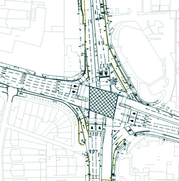
Fig. 9a: Farnham Road / Tuns Lane (The Three Tuns) junction – existing arrangement
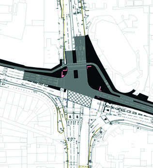
Fig. 9b: Farnham Road / Tuns Lane (The Three Tuns) junction – proposed arrangement
- Windmill Road / Beckwell Road junction (see Figs. 10a and 10b below):
- Replacement of the existing cyclist and pedestrian staggered signalised crossing with a straight-across cyclist and pedestrian signalised crossing
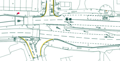
Fig. 10a: Windmill Road / Beckwell Road junction – existing arrangement
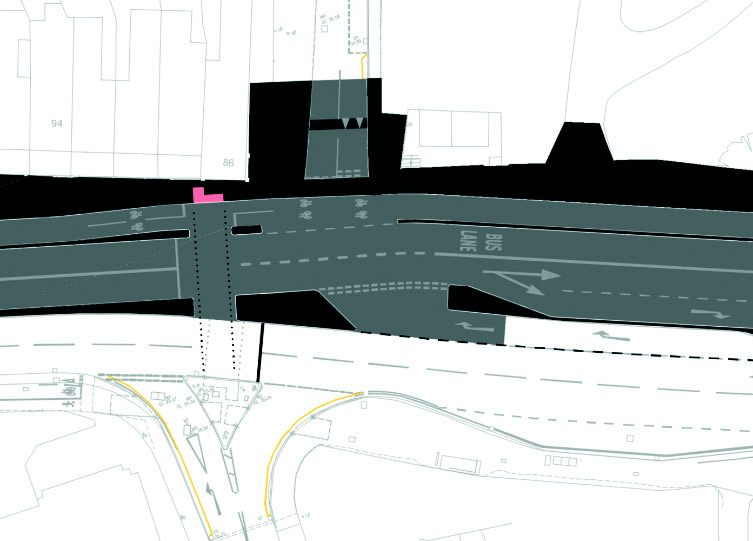
Fig. 10b: Windmill Road / Beckwell Road junction – proposed arrangement
- Ledgers Road / Stoke Poges Lane junction (see Figs. 11a and 11b below):
- Removal of the eastbound right turn from the A4 Bath Road into Ledgers Road; as a result, approximately 70 additional vehicles per day would turn right from the A4 Bath Road into Montem Lane to access Ledgers Road, and extra traffic signal green time would be given to that right turn
- Introduction of new countdown timers for pedestrians at existing signalised crossings (these show the amount of time left to cross the road before the red man appears – see Image 2 below)
- Removal of the signalised pedestrian crossing on the east side of the junction (crossing the A4 Bath Road)
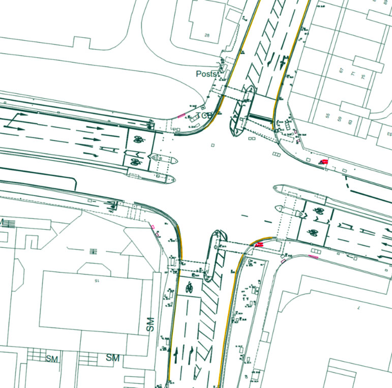
Fig. 11a: Ledgers Road / Stoke Poges Lane junction – existing arrangement
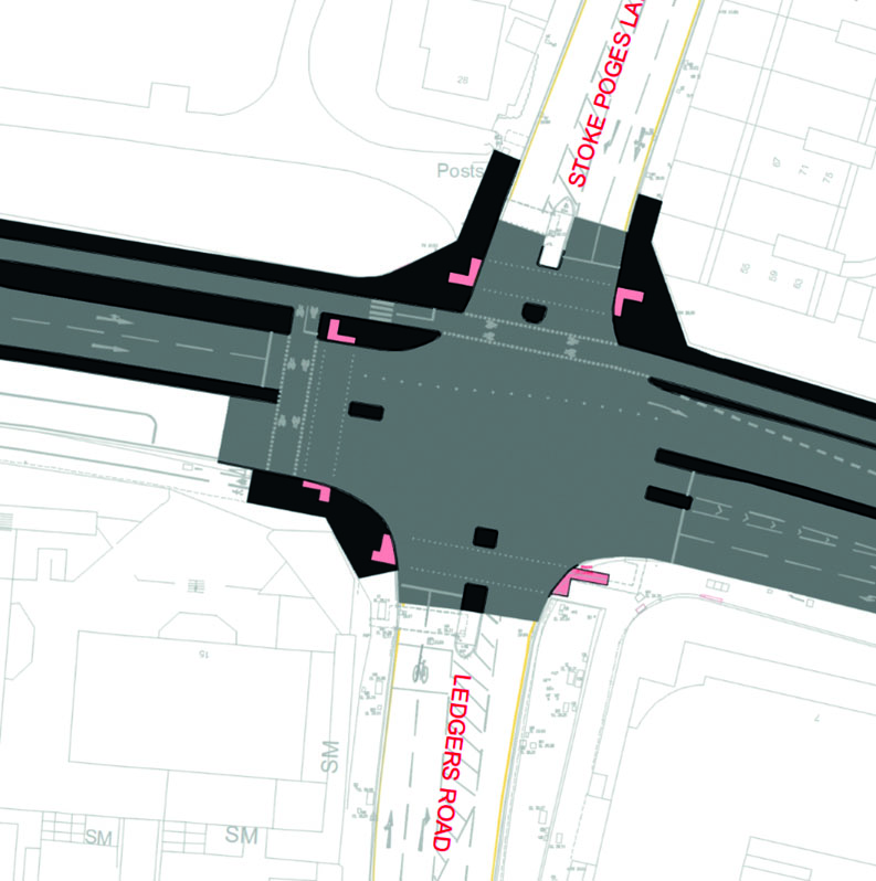
Fig. 11b: Ledgers Road / Stoke Poges Lane junction – proposed arrangement
- William Street / Stoke Road (Heart of Slough) junction (plan extracts not available):
- Introduction of new countdown timers for pedestrians at existing signalised crossings (these show the amount of time left to cross the road before the red man appears – see Image 2 below)
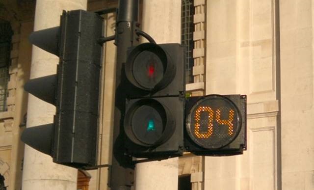
Image 2: A countdown timer (Source: Traffic Choices (Bristol))
Why your views matter
Why your views matter
We want to know your views on the design of the proposed cycle route and road safety improvements, to try to ensure that we haven’t missed anything important.
What happens next?
We will take your views on the A4 Cycle Route and Road Safety Improvements into account when finalising the design. We will update affected residents, businesses, and stakeholders before we start construction.
Further information
Slough Borough Council’s Cabinet took a decision on the A4 Cycle Route on 17 July 2023, agenda item 10. The following documents relate to this:
Decisions 17072023 1830 Cabinet
If you would like further information to enable you to respond, or a copy of this information in another format or language, please:
- email us at TransportPlanning@slough.gov.uk , or
- write to us at A4 Cycle Route Consultation – Enquiry, Transport, Slough Borough Council, Observatory House, 25 Windsor Road, Slough SL1 2EL, or
- call us on 01753 475111 (asking for a message about "A4 Cycle Route Consultation – Enquiry" to be passed to the Transport team), or
- visit one of our drop-in sessions, where you can talk to one of our officers in person:
- Cippenham Baptist Church, 11 Elmshott Lane, Slough SL1 5QS: Thursday 24 August 2023, 3-7pm
- The Curve, William Street, Slough SL1 1XY: Wednesday 30 August 2023, 10am-4pm
- Cippenham Baptist Church, 11 Elmshott Lane, Slough SL1 5QS: Thursday 14 September 2023, 3-7pm
How to respond
Please, if possible, respond using the online survey form below:
If you are unable to use the online survey form, please instead respond:
- by email to TransportPlanning@slough.gov.uk , or
- in writing to A4 Cycle Route Consultation – Response, Transport, Slough Borough Council, Observatory House, 25 Windsor Road, Slough SL1 2EL, or
- using a paper survey form (included in a leaflet about this consultation) that you can pick up from Cippenham Library or The Curve and return to us, or
- visit one of our drop-in sessions, where you can respond using a paper survey form or talk your response through with one of our officers:
- Cippenham Baptist Church, 11 Elmshott Lane, Slough SL1 5QS: Thursday 24 August 2023, 3-7pm
- The Curve, William Street, Slough SL1 1XY: Wednesday 30 August 2023, 10am-4pm
- Cippenham Baptist Church, 11 Elmshott Lane, Slough SL1 5QS: Thursday 14 September 2023, 3-7pm
Please respond by 11.59pm on Friday 29 September 2023.
What happens next
Thank you for giving us your views on the A4 Cycle Route and Road Safety Improvements. We will take these into account when finalising the design. We will update affected residents, businesses, and stakeholders before we start construction.
Events
-
Drop-in session - Cippenham Baptist Church
From 24 Aug 2023 at 15:00 to 24 Aug 2023 at 19:00Cippenham Baptist Church, 11 Elmshott Lane, Slough SL1 5QS
Visit one of our drop-in sessions, where you can talk to
one of our officers in person and view full plans of the
proposed changes, respond using a paper survey form, or talk
your response through with one of our officers -
Drop-in session - The Curve
From 30 Aug 2023 at 10:00 to 30 Aug 2023 at 16:00The Curve, William Street, Slough SL1 1XY
Visit one of our drop-in sessions, where you can talk to
one of our officers in person and view full plans of the
proposed changes, respond using a paper survey form, or talk
your response through with one of our officers -
Drop-in session - Cippenham Baptist Church
From 14 Sep 2023 at 15:00 to 14 Sep 2023 at 19:00Cippenham Baptist Church, 11 Elmshott Lane, Slough SL1 5QS
Visit one of our drop-in sessions, where you can talk to
one of our officers in person and view full plans of the
proposed changes, respond using a paper survey form, or talk
your response through with one of our officers
Audiences
- Anyone from any background
Share
Share on Twitter Share on Facebook