Destination Farnham Road - Proposed Design Consultation
Overview

We consult residents, commuters, businesses, and stakeholders to understand what people think about proposed developments, changes to our roads and pavements, or other traffic-related issues.
Following our consultation last year, and a successful multi-million pound bid to the government’s Levelling Up Fund Round 2, we have developed a proposed design for major improvements to Farnham Road and its side roads, including:
- a high quality public space, and a reduced speed limit (20mph), through the main shopping area
- a new off-road, two-way cycle route, upgraded roads and footways, new / upgraded signalised and unsignalised pedestrian and cycle crossing facilities, better street lighting where needed, upgraded bus stops, and new parking facilities, along most of Farnham Road
- improvements to the small park, and changes to the car park, at the junction of Sheffield Road
- widened advisory cycle lanes, and further road improvements, along most of Sheffield Road
- a ‘cycle street’ along most of Furnival Avenue
We would like your views on this proposed design.
Background
The Levelling Up Fund Round 2 is designed to invest in infrastructure that improves everyday life across the UK. The £4.8 billion fund will support town centre and high street regeneration, local transport projects, and cultural and heritage assets. It aims to foster a sense of community, local pride and belonging, by empowering local leaders and communities, improving public services, and increasing productivity in areas that are lagging behind.
The Destination Farnham Road scheme aims to create an attractive, high quality public space that will:
- enhance the local economy and help to create jobs by supporting businesses in the area
- improve the busy and active space that residents, businesses and visitors use every day
- help local residents who are impacted by the volume of people and cars in the area
We want to produce a design for the changes to the area that addresses various existing and potential future problems such as:
- traffic congestion
- high demand for parking
- inconsiderate parking
- crime and anti-social behaviour
- rubbish left on the street
- road safety concerns
- poor air quality
We want to create, in the main shopping area, a high quality, appealing space and a pedestrian-oriented streetscape that benefits visitors who use any mode of transport, including car, motorcycle, foot, wheelchair, bicycle, e-scooter* and bus.
We also aim to improve access between the areas surrounding the main shopping area and with the rest of Slough by providing improved and safer facilities for vulnerable road users including pedestrians, bus users and cyclists, and by improving car parking.
In June 2022 we submitted a bid to the Department for Levelling Up, Housing and Communities’ (DLUHC) Levelling Up Fund Round 2 (LUF2) for the scheme, as described below, and in February 2023 we were awarded £9.3 million to design and build the scheme. As part of the bid we allocated a further £1 million in funds from other grants as match funding was required by DLUHC, so the total value of the scheme is approximately £10.3 million. These funds are only available for the Destination Farnham Road scheme and cannot be spent on other services.
As part of our preparation for the funding bid we consulted residents, commuters, businesses and stakeholders in June 2022 to give them an opportunity to have their say on the vision for the Destination Farnham Road scheme, and to provide some general feedback on how it could be improved. We asked people how they currently used the areas and its facilities, to list any existing problems that needed addressing, and to tell us about improvements they would like to see and any potential issues with our vision. The consultation was split into two elements: Farnham Road Public Realm and Farnham Road Bus Accessibility.
We also visited local businesses in June 2022 to ask about their vision for Farnham Road, including asking them what issues were most important to them and asking them and their customers what they thought about Farnham Road at the time.
We would now like to update you on how the Destination Farnham Road scheme is progressing and ask for your views on a proposed design which aims to fulfil the vision for the scheme and to address some of the issues which emerged from the consultations in June 2022.
* using a future e-scooter hire scheme, and / or private e-scooters if these are made legal in future
What are we proposing?
Our proposed design extends along Farnham Road between the Cumberland Avenue roundabout and the A4 Bath Road.
The following ‘artist’s impressions’ show parts of the proposed design:
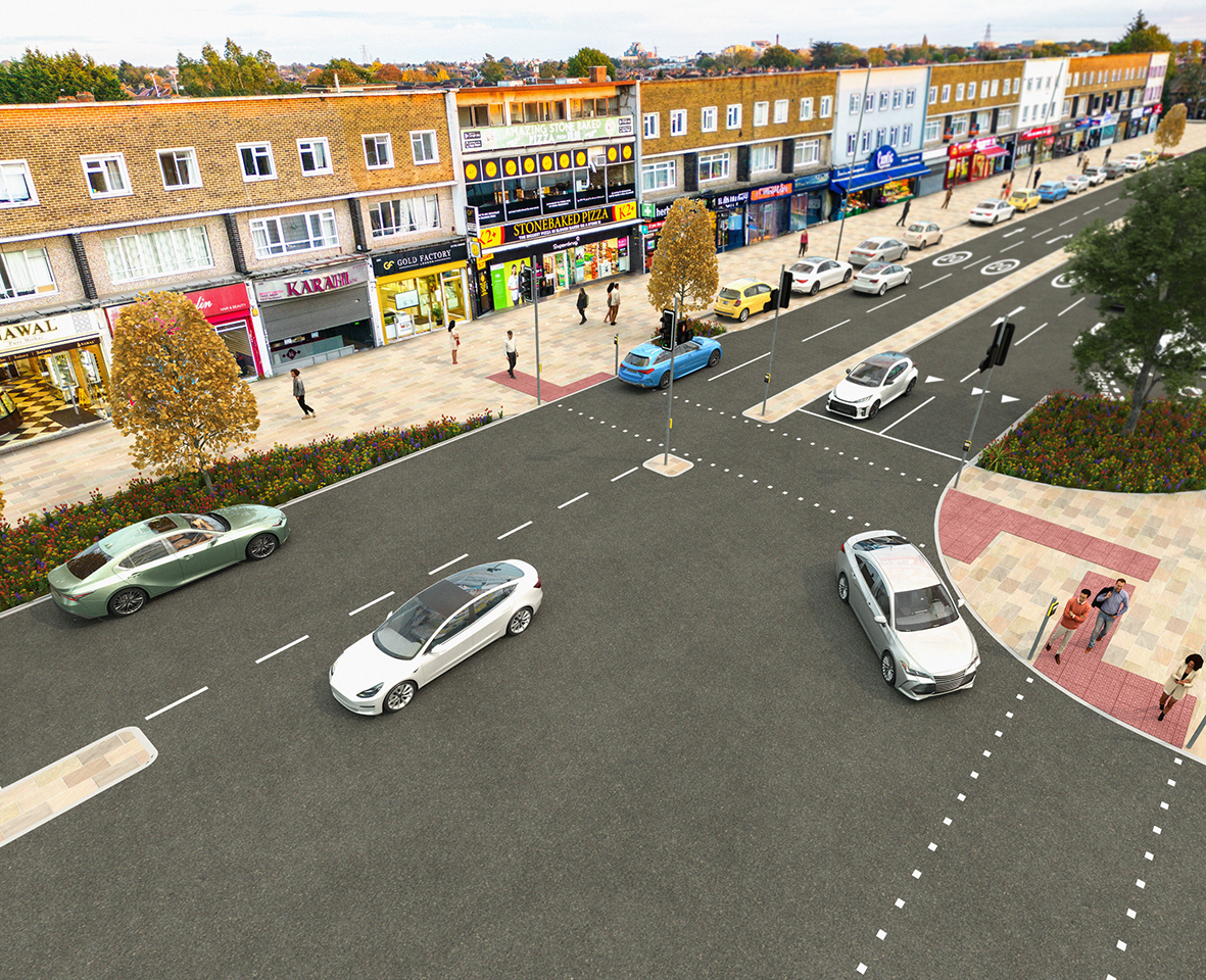 Image 1: Artist’s impression – Farnburn Avenue Junction Looking South-East
(Artist: Yogi Comms)
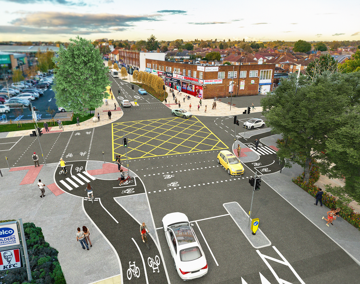 Image 2: Artist’s impression – Sheffield Road Junction Looking North
(Artist: Yogi Comms)
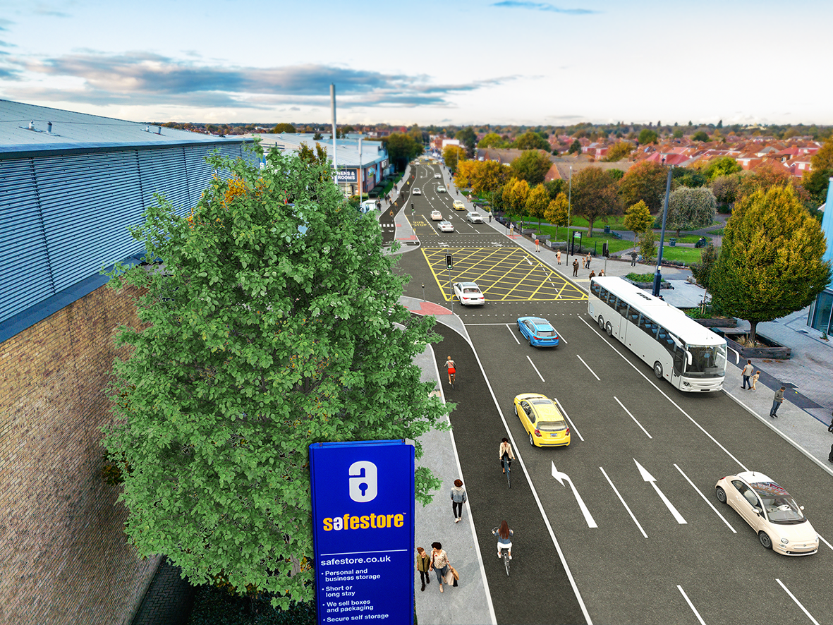 Image 3: Artist’s impression – Buckingham Avenue Junction Looking North
(Artist: Yogi Comms)
Our proposed design includes (also see images below):
- a high quality public space through the main shopping area between Essex Avenue and Sheffield Road, creating a distinctive character that showcases the local area and its architectural quality, upgrading many elements of the street and with traffic calming features
- a reduced speed limit (reduced from 30mph to 20 mph) through the main shopping area between Essex Avenue and Sheffield Road
- a new off-road, two-way cycle route on the west side of Farnham Road (with either a stepped (segregated), approximately 2.5 metre wide cycle lane or the use of shared use footway or shared space) – this would directly link with the new A4 Cycle Route at the junction of Farnham Road and the A4 Bath Road
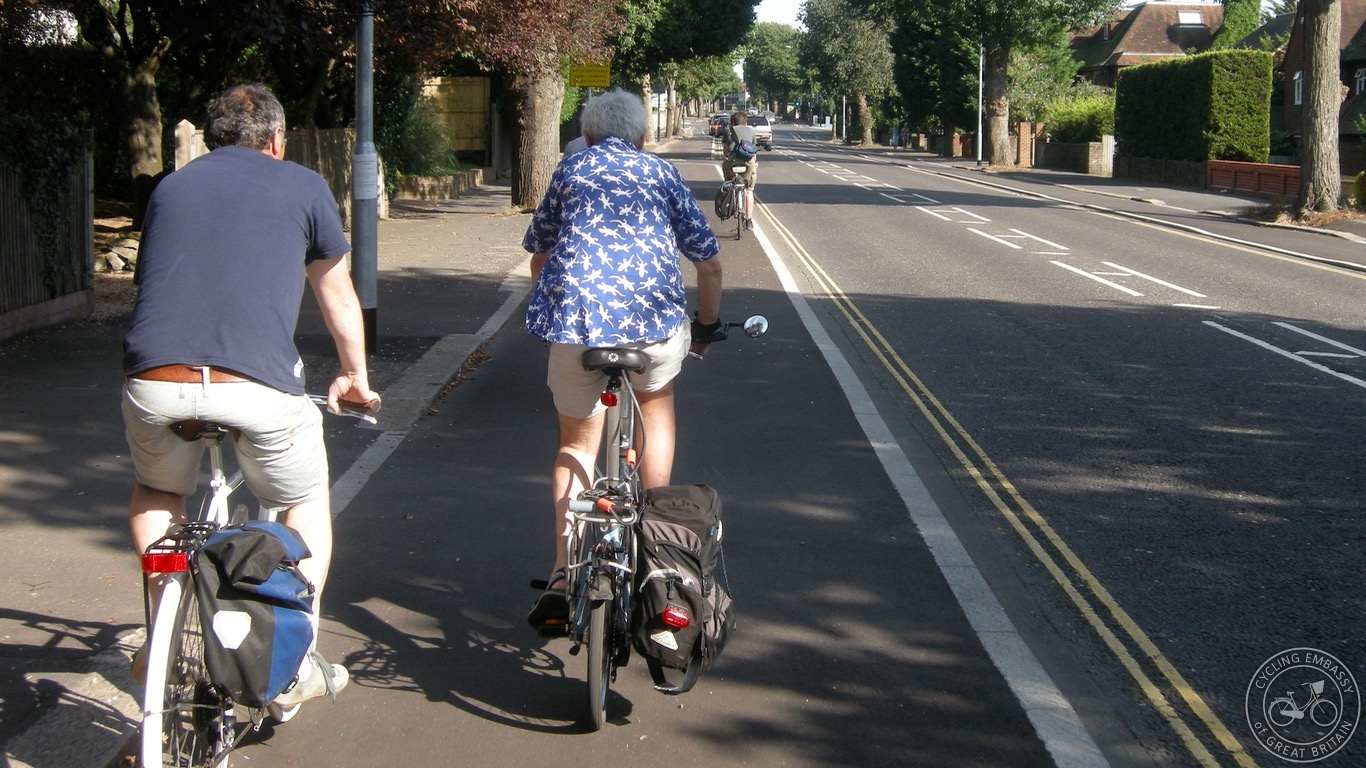
Image 4: A stepped cycle lane
(Source: Cycling Embassy of Great Britain)
- upgraded roads and footways on parts of Farnham Road, including resurfacing, distinctive / coloured paving materials, new road markings, upgraded traffic signals, and raised tables at some junctions and through part of the area
- slight shortening of the existing southbound bus lanes at their southern ends to allow more vehicle queueing space
- realignment of some road and footway, including removal of service roads, removal of some central reservation, and reduction in width of some central islands, to make the best use of space
- new parallel / dual zebra crossings (zebra crossings which also allow cyclists to cross alongside at the same location) on all four arms of the Cumberland Avenue roundabout
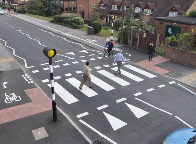
Image 5: A parallel / dual zebra crossing
(Source: Essex Active Travel Design Portal)
- new / upgraded pedestrian and cycle signals to cross Essex Avenue, Furnival Avenue, Farnburn Avenue and Montrose Avenue
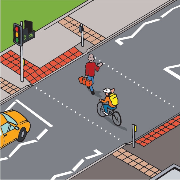
Image 6: A crossing with pedestrian and cycle signals
(Source: South Yorkshire Safer Roads Partnership)
- new segregated (pedestrian and cycle) signalised crossings at the Sheffield Road and Buckingham Avenue junctions
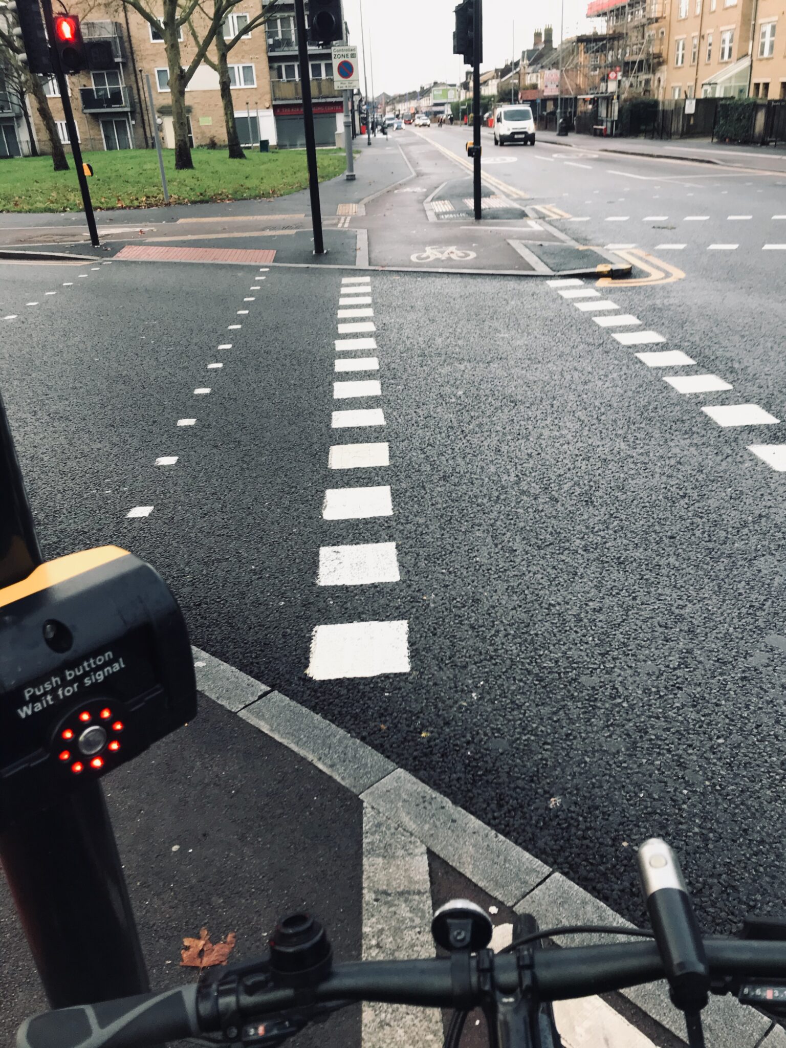
Image 7: A segregated (pedestrian and cycle) signalised crossing
(Source: Chris Lord, Epping Forest Transport Action Group)
- continuous footway across some side roads
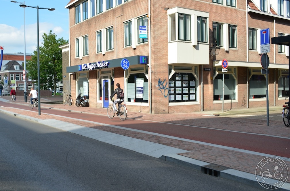
Image 8: A continuous footway across a side road
(Source: Cycling Embassy of Great Britain)
- review of existing street lighting, with better street lighting and additional lighting features where needed
- amenity areas outside shops and restaurants with planting and space for seating, new benches to increase the number of places to sit, and wayfinding totems
- upgraded bus stops, with lay-bys removed and parking restrictions enhanced to ensure that buses can always access the kerb, clearer footway access, upgraded bus shelters, and improved information
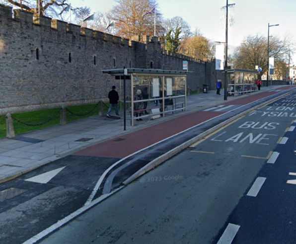
Image 9: An upgraded bus stop
(Source: Google Maps)
- new parking facilities, including new limited waiting vehicle parking pads (parking bays forming part of the footway) between the Cumberland Avenue roundabout and Sheffield Road, and relocated vehicle parking with new limited waiting ‘echelon’ (diagonal) parking bays in the main shopping area between Essex Avenue and Sheffield Road
- new electric vehicle charging points, and new cycle parking, in the main shopping area between Essex Avenue and Sheffield Road
Additionally:
- junction of Sheffield Road:
- improvements to the small park, including better lighting and planting
- the existing car park to remain, but with entry from Sheffield Road
- along Sheffield Road between Farnham Road and Baylis Court Nursery School:
- widened advisory cycle lanes on both sides of the road – these would link the cycle route on Farnham Road with the existing National Cycle Network route 461 crossing Sheffield Road, which links with Salt Hill Park and surrounding areas
- further road improvements, including resurfacing and new road markings, with removal of the central road marking along part of the road
- along Furnival Avenue between Farnham Road and the cycle path linking with Greenside:
- a ‘cycle street’ (a street designed to handle large volumes of cycling, but very low volumes of motor traffic) to increase cycling – this would link the cycle route on Farnham Road with Britwell and Kennedy Park
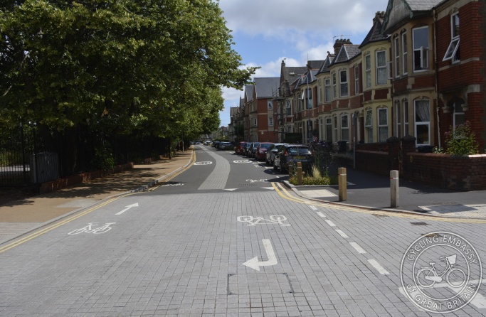
Image 10: A cycle street
(Source: Cycling Embassy of Great Britain)
The following plans show the proposed design in more detail:
Plan Sheet 1 of 6 – Farnham Road between Cumberland Avenue roundabout and Lidl
Plan Sheet 2 of 6 – Farnham Road between Lidl and Sheffield Road
Plan Sheet 3 of 6 – Farnham Road between Sheffield Road and Railway Bridge
Plan Sheet 4 of 6 – Farnham Road between Railway Bridge and A4 Bath Road
Plan Sheet 5 of 6 – Sheffield Road
Plan Sheet 6 of 6 – Furnival Avenue
We will only be making changes to areas that are adopted public highway (areas that are owned and maintained by Slough Borough Council).
Header image: Artist’s impression – Sheffield Road Junction Looking North
(this is a cropped version of Image 2 shown above, so some, but not all, of the alt text for Image 2 applies to this)
(Artist: Yogi Comms)
Why your views matter
We want to know your views on this proposed design for Destination Farnham Road to help shape the scheme and to try to ensure that we have not missed anything important.
What happens next?
We will take your views on the proposed design for the Destination Farnham Road scheme into account when preparing the detailed design and preparing a report to the Slough Borough Council Cabinet members for their decision. We will update affected residents, businesses, and stakeholders before we start construction.
For information on the Destination Farnham Road scheme in future, please see www.slough.gov.uk/DestinationFarnhamRoad (this web page is not yet available).
Further information and how to respond
Background information:
Levelling Up Fund Round 2 Outcome Letter
Slough Borough Council Significant Decision Report December 2023
List of successful bidders for Levelling Up Fund Round 2
If you would like further information to enable you to respond, or a copy of this information in another format or language, please:
- email us at TransportPlanning@slough.gov.uk, stating "Destination Farnham Road - Proposed Design Consultation - Enquiry" in the subject line, or
- write to us at Destination Farnham Road – Proposed Design Consultation – Enquiry, Transport, Slough Borough Council, Observatory House, 25 Windsor Road, Slough SL1 2EL, or
- call us on 01753 475111 (asking for a message about "Destination Farnham Road – Proposed Design Consultation – Enquiry" to be passed to the Transport team), or
- visit one of our drop-in sessions, where you can view the plans showing the proposed design in more detail (as attached above) and talk to one of our officers in person:
- The Centre, Farnham Road, Slough SL1 4UT:
- Tuesday 23 January 2024, 2-7pm
- Thursday 25 January 2024, 10am-4pm
- Thursday 1 February 2024, 3-7pm
- The Centre, Farnham Road, Slough SL1 4UT:
Please, if possible, respond using the online survey form below.
If you are unable to use the online survey form, please instead respond using a paper survey form (included in a leaflet about this consultation) that you can pick up from Observatory House, 25 Windsor Road or from Britwell Library, Wentworth Avenue (from 18 December 2023) and return to us, using one of the above methods (changing 'Enquiry' to 'Response'), or visit one of our drop-in sessions and ask one of our officers to help you make your response.
Please respond by 11.59pm on Sunday 11 February 2024.
What happens next
Thank you for giving us your views on the proposed design for the Destination Farnham Road scheme. We will take these into account when preparing the detailed design and preparing a report to the Slough Borough Council Cabinet members for their decision. We will update affected residents, businesses, and stakeholders before we start construction.
For information on the Destination Farnham Road scheme in future, please see www.slough.gov.uk/DestinationFarnhamRoad (this web page is not yet available).
Events
-
Drop-in session - The Centre
From 23 Jan 2024 at 14:00 to 23 Jan 2024 at 19:00The Centre, Farnham Road, Slough SL1 4UT
Visit one of our drop-in sessions, where you can view the plans showing the proposed design in more detail (as attached above), talk to one of our officers in person, and ask one of our officers to help you make your response
-
Drop-in session - The Centre
From 25 Jan 2024 at 10:00 to 25 Jan 2024 at 16:00The Centre, Farnham Road, Slough SL1 4UT
Visit one of our drop-in sessions, where you can view the plans showing the proposed design in more detail (as attached above), talk to one of our officers in person, and ask one of our officers to help you make your response
-
Drop-in session - The Centre
From 1 Feb 2024 at 15:00 to 1 Feb 2024 at 19:00The Centre, Farnham Road, Slough SL1 4UT
Visit one of our drop-in sessions, where you can view the plans showing the proposed design in more detail (as attached above), talk to one of our officers in person, and ask one of our officers to help you make your response
Audiences
- Anyone from any background
Share
Share on Twitter Share on Facebook